Walking the Woods & Trails
Throughout Carson Road Woods (CRW) there are marked trails that launch from the main path (also part of Lawrence Hopewell Trail - LHT) which runs through the pristine 183 acres. There are 2 parking areas, one at each end of Carson Road and on street parking at Bellevue Terrace entrance. Please be courteous of neighbors, curb and leash your dogs.
We have provided several suggested loops using mapmywalk.com and if you download the app and press the 'Routes' option, you will see numerous more. Add your own favorites by launching the app and saving your walk using the 'Public' setting. If you have images that you'd like us to include in our galleries, please submit them here.
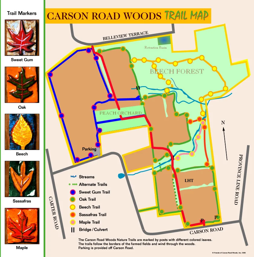
**A full trail map is provided at the bottom of this page.
Sweetgum Trail (red) -- heads slightly northwest off north along the western part of the north section of the property and then northeast to hook up with the Beech and Oak Trails.
Sweet Gum / Benedek Circle Loop, 2.1 Mile: Map

Oak Trail (green) -- heads south down the middle of the property.
Oak Trail / Squibb Lake Loop, 3.35 Mile: Map
Beech Trail (yellow) -- from the Oak Trail, it heads slightly northeast off east to the Sassafras Trail.
Beech / Sweet Gum Loop, 2.5 Mile: Map
Sassafras Trail (orange) -- from the Beech Trail, it heads south along the eastern edge of the property.
Sassafras / LHT Loop, 1 Mile: Map
Stream-Maple Leaf Trail-- a side trail thatleads to a stone-edged bridge.
Maple Stream / Oak Loop, 1.2 Miles: Map